
gvSIG applications in East Africa – Kenya and Somaliland
The availability of well structured geographic data together with the possibility of a regular updating, represent a very important tool worldwide and in particular in developing countries.
Somaliland local government is trying to develop a policy of transfer of knowledge in different sector and, among these, the capacity of urban management and planning. In this framework, GISMAP has supported the Italian ONG Terre Solidali, to train the Gabiley Municipality technical staff and make them able to produce precision “cadastral” maps of buildings together with a socio-economic survey.
Kenya Forest Council is carrying out, in the scheduled activities of the WIRE Forest project implemented by the Italian NGO CEFA, a complete field survey of the surrounding hilly forested areas requiring a GIS solution to better store, update and analyse the collected field data.
GISMAP, in both cases, has offered a similar solution adapting the proposal to the different needs of the partners.
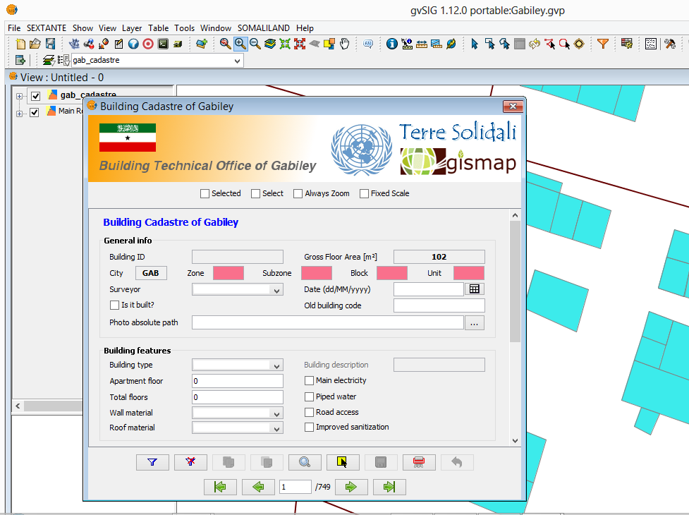
In Gebiley (Somaliland) GISMAP has defined together with local staff one complete field form identifying as well the domains for any single field to be collected and entered providing as well a training on the job on how to use the differential GPS, for having high precision measurements, and how to store, edit, and manage these data.
A customized gvSIG extension has been developed and a user friendly interface, based on NavTableForms, to enter the data through drop-down lists and check boxes has been implemented.
This customized extension guides the user throughout the entire work flow from GPS points data load, conversion into 2D shapefile, creation of polygons by derivative geometries and data entry by the customized form previously described.
After a first period of data collection, a training on the job on how to use this user interface has been provided to the final users.
In Wire Forest area, GISMAP has adopted the same procedure, developing the training in remote instead than on site. The form has been also in this case customized according to users need and due to the lower precision required, on field points have been collected by ordinary GPS.
Through this tool, two technical offices in different sectors and countries have been trained and provided with a GIS tool making them able to map actual situation and plan future activities.
It has to be taken into consideration that the adoption of a fully open source technology ensures future sustainability of the data collection, storage and management as well as the possibility to stay in touch with dynamic web communities.
The implementation of a user interface to enter data through drop-down list and check boxes extremely reduces the risk of mistyping that is really frequent and make GIS solutions unable to perform correct queries on attributes.
- 9th International gvSIG Conference: