
Analisys of contaminants and salinity in the Minho's river for the European Project
The project TEAM-Minho, led by the University of Vigo, brings together scientific partners and water administrations on both sides of the river Minho to develop common tools for the coordinated implementation of the Water Framework Directive in its estuary.The aim of this project is the establishment of uniform scientific criteria, valid for Spain and Portugal, allowing the definition, referencing and classification of ecological status of transitional water bodies in southern Galicia and northern Portugal. Also the transfer of results to relevant public institutions, local social agents and society in general, in order to assist in the implementation of the WFD by establishing a framework for effective protection of transitional waters.
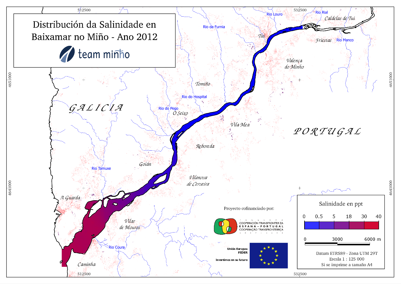
Taking into account the objectives of the project, the first need identified was the design of sampling to be performed to determine the initial environmental state of the estuary. To facilitate this, we conducted a preliminary sampling of salinity and the distribution of different organisms (an alga, a bivalve and a gastropod) in the estuary at high and low tide. It was also conducted a literature research on previous studies in the estuary to determine the spatial distribution of different physicochemical parameters (salinity, phosphate, ammonium, nitrate and nitrite), at both at low and high tide.
Importantly remarkable is the fact that free software is going for the implementation of Geographic Information System, from the development of data and metadata, spatial analysis and data storage to the generation of reports and maps.
Considering the large volume of data being generated in the course of the project, and the importance of the space component, it was decided their integration into a GIS, adopting as database management system the combination PostgreSQL and PostGIS.
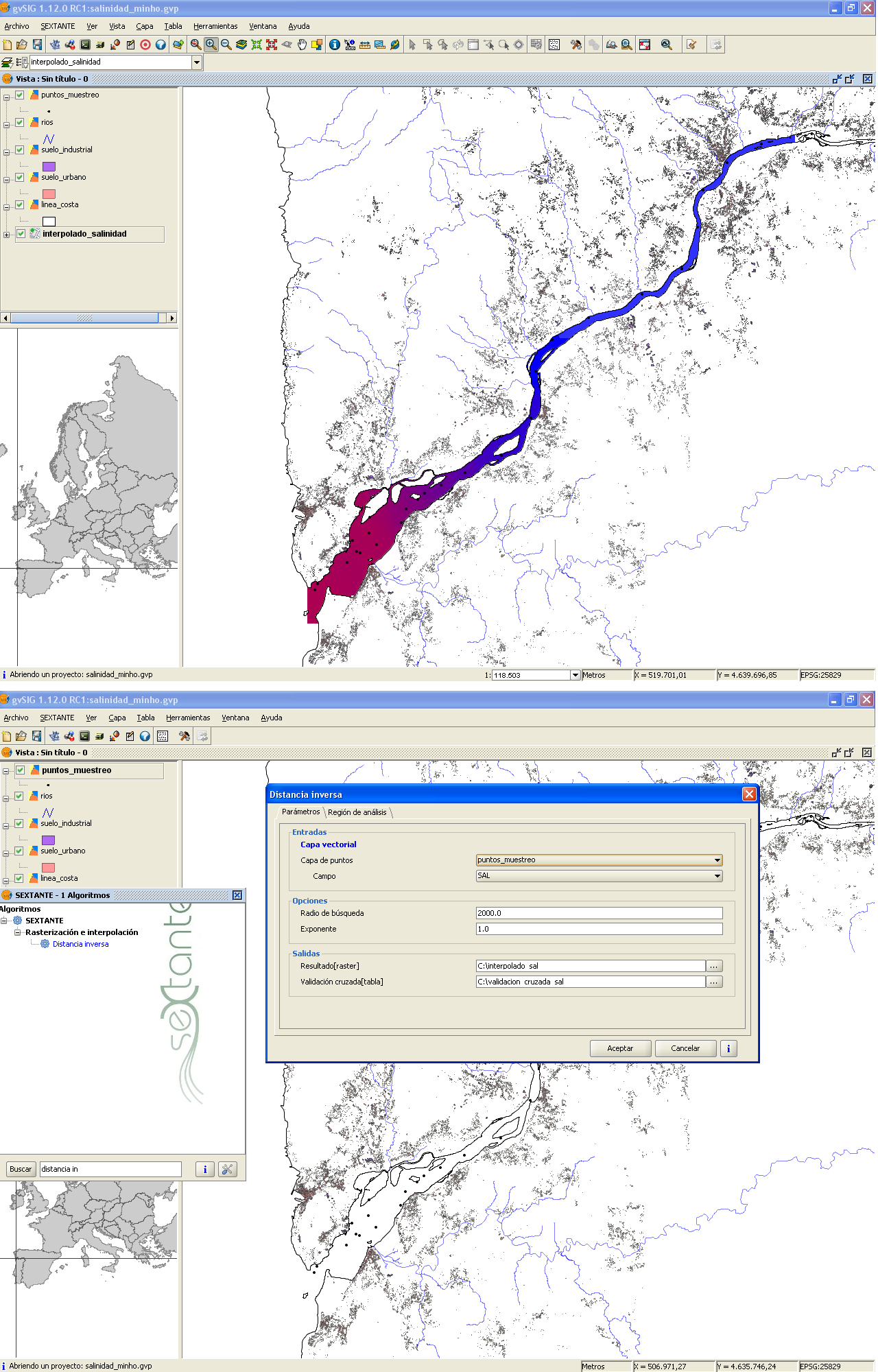
For creating, editing, geoprocessing and display of spatial data gvSIG and SEXTANTE were chosen, while for mapping it was chosen Quantum GIS.
To prepare the metadata for all data generated CatMDEdit software was used.
Thanks to the capacities of gvSIG and SEXTANTE, raster files were generated from previous sampling data and articles from the literature research with the information of the spatial distribution of different physicochemical processes in the estuary of the Minho, and also vector files were generated with the distribution of the organisms studied in both shores of the river.
Once we knew the spatial distribution of the physicochemical parameters and organisms, we designed the sampling to be carried out during the project.
The first sampling campaign was conducted in late May, having planned a second sample collection for fall.
As results are obtained from the different performed analyses, those will be included in the database for further processing, display and future publication.
Two are the main benefits:
- Reducing costs for the project by using free software, which do not imply a license purchase.
- The integration of all information obtained in the framework of the project in a GIS, which will permit:
- Analyses and spatial queries.
- Generation of new layers of information.
- Development of maps and graphical representation of the information obtained.
- Elaboration of reports and didactic materials for the justification and development of project tasks.
- To facilitate decision-making.
- Paving the way for future web mapping service.